
LLANGADOG
Click here for a copy of the full report
SUMMARY
Llangadog is unusual for southwest Wales in having probably pre-Anglo-Norman conquest origins and not having any clear Anglo-Norman influence as it developed into a town in the twelfth/thirteenth century. It was always a small town and did not grow much beyond its medieval limits until well into the nineteenth century. Archaeological investigations consist of two small watching briefs and so it is unknown what archaeological deposits survive.
KEY FACTS
Status: Weekly market and annual fairs recorded. No town charter.
Size: 1326 33 burgesses.
Archaeology: Nothing of significance.
LOCATION
Llangadog lies on the south side of the Towy valley, Carmarthenshire, on a tongue of flat land between the Afon Sawdde and Afon Brân (SN 706 284). The Towy valley provides easy access west to western Carmarthenshire and Pembrokeshire and to the north and east into mid-Wales. Llandeilo lies 9km down the valley to the southwest and Llandovery 8.5km up the valley to the northeast. The Sawdde valley provides a route over the Black Mountain to the south.
HISTORY
The history of Llangadog is sketchy. The church of St Cadog was probably founded prior to the Anglo-Norman conquest of southwest Wales and is generally considered to be the church referred to in the Book of Llandaff, although some authorities dispute this. The Anglo-Normans established Castell Meurig 1km to the south of the church during their conquest of southwest Wales, probably in the early twelfth century, although the earliest reference to it is in 1160. It was destroyed in 1209. It is an earth and timber motte and bailey castle that does not seem to have been converted to stone.
Unlike other towns in southwest Wales a settlement did not develop outside the castle but around the church. The reason for this is unclear, but the Black Book of St David’s of 1326 records 33 burgesses all with Welsh names and it may be that Llangadog was unusual in being a pre-Anglo-Norman settlement centred on the church which developed into a Welsh town. Llangadog came under the patronage of the Bishops of St Davids. In 1281 Bishop Bek granted a right to hold a weekly market and annual fairs and in 1283 he founded a college for a precentor and 21 canons; this was short-lived and was transferred to Abergwili in 1287; doubt has been expressed whether the intention was ever carried out. No town charter is known.
The later history of Llangadog has not been researched. The 1839 tithe map shows a small settlement of essentially one street; it is likely this was the extent of the town for much of the medieval period and into the nineteenth century. It was only in the twentieth century that development to the north and south occurred.
MORPHOLOGY
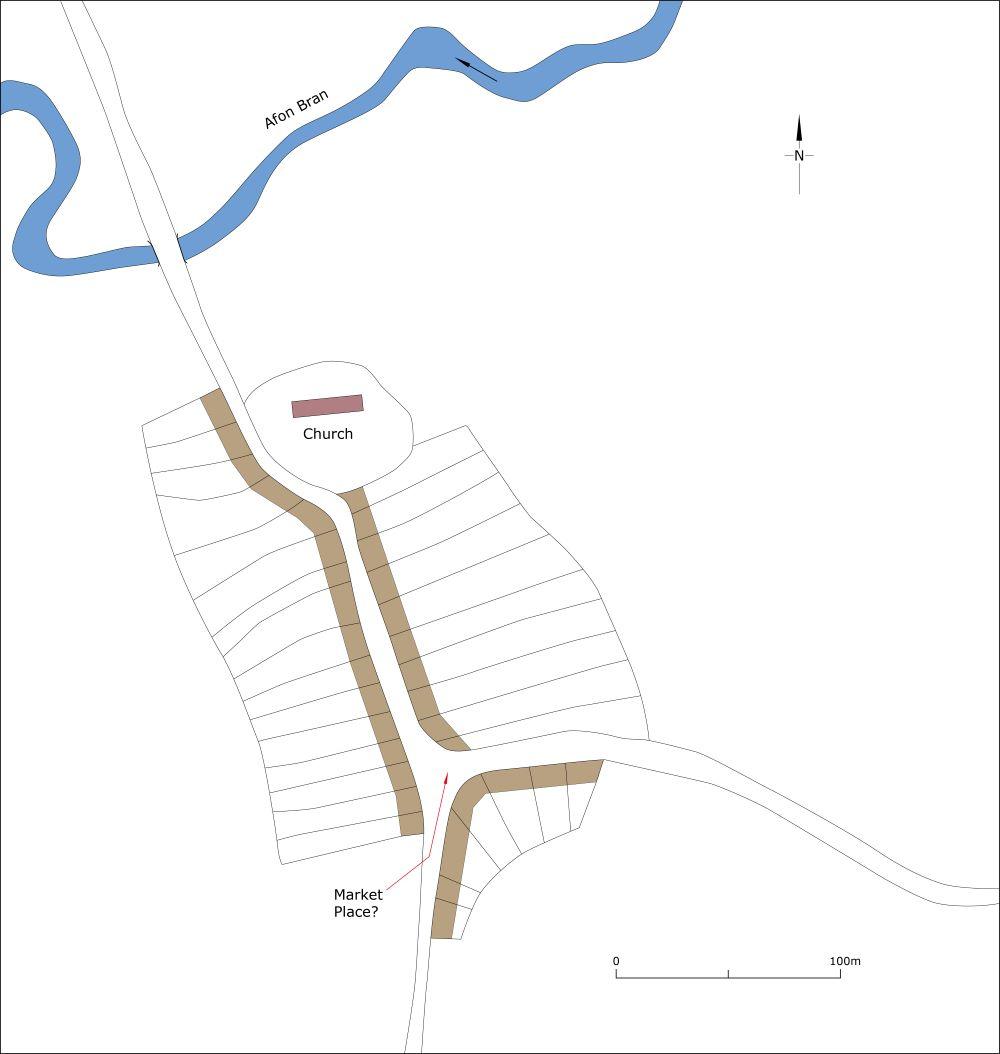
Prior to modest expansion from the end of the nineteenth century Llangadog consisted of one 250m-long street (Church Street), with the river crossing of the Afon Brân at the north end and Queen’s Square at the south end. Church Street curves around the roughly circular churchyard of St Cadog’s indicating it and the town post-date the foundation of the church. As noted above, the 1839 tithe map shows the extent of the town as it probably was from the thirteenth century to the nineteenth century. The street frontages on both sides of Church Street present an almost unbroken façade of mostly nineteenth century houses and commercial properties, including several listed buildings. It is assumed that the triangular-shaped Queen’s Square was the site of the weekly market granted to the town in 1281.

Conjectural plan of Llangadog as it may have been c.1320.
