
LLAWHADEN
Click here for a copy of the full report
SUMMARY
The Bishop of St Davids established at castle Llawhaden in 1115. A settlement probably developed outside the castle gates. In 1281 Bishop Bek founded a town and encouraged settlers. Initially the town was successful as in 1326 126 burgesses are recorded holding 174½ burgage plots, making it one of the largest towns in southwest Wales. However, the town of Llawhaden drops out of history and it is assumed it went into severe decline following the European-wide population crash of the mid-fourteenth century and was reduced to a village. As part of his foundation Bishop Bek established a hospital at the west end of the town – this was dissolved in 1535; one building survives.
KEY FACTS
Status: 1281 granted the right to hold a weekly market and two annual fairs. No town charter.
Size: 1326 126 burgesses.
Archaeology: Excavation at the medieval hospital revealed extensive archaeological deposits.
LOCATION
Llawhaden lies in central Pembrokeshire (SN 072 174). It now has two centres: Llawhaden Castle and village occupy level ground at 90m above sea level; the parish church, bridge and mill lie to the east at the foot of a steep slope on the valley floor of the Eastern Cleddau at 20m above sea level. Narberth lies 5km to the southeast and Haverfordwest 12 km to the southwest. The former borough of Wiston lies 4 km to the west. Llawhaden is now bypassed – the A40 trunk road runs 2 km to the south but formerly the town lay on the main east/west route with Llawhaden bridge historically the lowest bridging point of the Eastern Cleddau.
HISTORY
There is good evidence for pre-Anglo-Norman religious use of the site of the parish church of St Aidan in the form of a Celtic dedication (St Aidan) and the presence of an early Christian monument. In the tenth century Llawhaden is listed as one of the seven bishop houses of Dyfed.
Llawhaden was a possession of the Bishop of St Davids; it was Bernard, who became the first Norman bishop in 1115, who built the first castle. The original earth and timber castle had been rebuilt in stone by the early thirteenth century, but it was Thomas Bek from his appointment as bishop in 1280 who transformed it into a major fortified mansion. In 1326 two gardens are mentioned as well as stone buildings within the walls and wooden buildings outside the walls.
In 1281 Bek granted licences for Llawhaden to hold a weekly market and two annual fairs. In 1287 he established a hospital under the rule of a prior charged with the care of ‘pilgrims, paupers, orphans, the old, weak and infirm’, and endowed it with land. Settlers, mostly English, were encouraged to immigrate to the new town and by 1326 126 burgesses held 174½ burgage plots, making it one of the largest towns in southwest Wales. Market dues, tolls and rentals and leases made Llawhaden the most lucrative of the bishop’s holdings. Building works are recorded at the castle in the second half of fourteenth century and later, but history is silent on the later fate of the town. It is assumed that its decline was as dramatic and rapid as its rise and that it did not survive the European-wide population crash of the mid-fourteenth century. In 1501 only the chapel element of the hospital remained active and this was dissolved in 1535, by which time Llawhaden was little more than a village.
MORPHOLOGY
St Aidan’s Church lies at the foot of a steep, wooded valley alongside the Eastern Cleddau just above what was until the post-medieval period the lowest bridging point of the river. Llawhaden Mill lies between the church and the bridge.

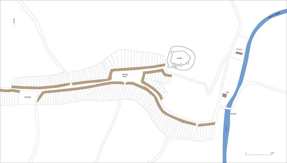
Schematic plan of Llawhaden as it may have been at its maximum extent in the medieval period, c. 1320.
Llawhaden Castle lies on the crest of the valley at 90m, over 70m higher than the church. It is likely that a settlement developed organically outside the castle gates prior to the foundation of the town in the late thirteenth century.
A triangular intersection of four small roads 200m to the west of the castle is assumed to be the site of the medieval marketplace. There is a loose grouping of nineteenth-century and more recent houses at this intersection. To the west of the marketplace the main road through the village runs on level ground. There is undeveloped land on both sides of this road, although the seventeenth century Llawhaden House (the house burnt down in 2000) with a collection of outbuildings occupies a prominent position on the north side. The remains of the medieval hospital lie at the west end of the village and most modern housing in Llawhaden lies to the north and east of the hospital. Property and field boundaries to the north and south of this main road locate the position of former burgages and excavations at the site of the hospital indicate former burgages lay to the west of this site and possibly to the south.
Low earthworks on the south side of a lane running down southeast from the marketplace to the valley floor mark the locations of abandoned burgages. Modern houses and gardens at the top end of this lane have encroached on some of these plots.
