
NEW MOAT
Click here for a copy of the full report
SUMMARY
New Moat is now a small village in central Pembrokeshire. The bishops of St Davids founded a castle, church and town at New Moat in the twelfth century and by 1326 42 burgesses are recorded holding 89 burgages. However, the town went into decline, probably during the fourteenth century. Archaeological evaluations have shown that significant medieval archaeological deposits associated with the town survive.
KEY FACTS
Status: Twice yearly fair.
Size: 1326, 42 burgesses held 89 burgages.
Archaeology: Evaluation excavations have revealed stratified medieval deposits.
LOCATION
New Moat lies at a height of 150m in central Pembrokeshire (SN 064 254) 14 km to the northeast of Haverfordwest and 11 km north of Narberth. The former towns of Wiston and Llawhaden lie to the southwest and south respectively. It lies in an agricultural landscape dominated by improved pasture with little arable.
HISTORY
The name New Moat implies a pre-existing defensive site in the vicinity, but it is not known whether this was several miles away or was at the location of ‘The Mote’ marked on Ordnance Survey maps to the south of the church. New Moat formed part of the estates of the Bishops of St Davids and it is they who founded the castle and developed the town. The form of New Moat motte and bailey castle indicates a twelfth century date for its foundation – there are no documentary sources to support this assertion. The motte stands up to 7m high, is 20m diameter across the top and is surrounded by a wet ditch. The oval bailey, the defensive circuit of which has been levelled, lies on the west side of the motte and measures 60m east/west, 145m north/south. It is likely that the earliest settlement developed in the bailey. There is no evidence to indicate that St Nicholas’s Church at New Moat had pre-Anglo-Norman foundations – the first reference was in c.1200 when it was granted to the newly founded Pill Priory in south Pembrokeshire. The same charter also granted to the priory ‘in the township of New Moat a burgage by the east gate and one burgage on the north side’. The mention of an east gate could be taken as an indication that the embryonic town lay within the bailey of the castle, or that the town was defended or that the burgage lay immediately outside the east gate of the castle. Whatever interpretation is made, it is clear that by c.1200 the town of New Moat was in existence or was in development. The Bishops of St Davids encouraged English settlers into their town – burgesses listed in the Black Book of St Davids are mostly English. In 1291, Bishop Bek granted New Moat a twice yearly fair. In 1326, 42 burgesses are recorded holding 89 burgages. History is quiet on the decline of New Moat but it is assumed it suffered, perhaps abandoned, during the European-wide population crash of the mid-fourteenth century.
The Scourfield family lived at The Mote from the late thirteenth century to 1780, becoming one of largest landowning families in the county. In the late eighteenth century they moved away from The Mote, but in 1830 the family moved back to New Moat and built a new mansion with extensive gardens, also called Mote, to the east of the village. The mansion is now a ruin.
John Speed listed New Moat as a principal town in Pembrokeshire in the early seventeenth century. However, this listing is likely to have been due to the Scourfields attempting to enhance their status by claiming possession of a town which was by then nothing more than a small village.
MORPHOLOGY
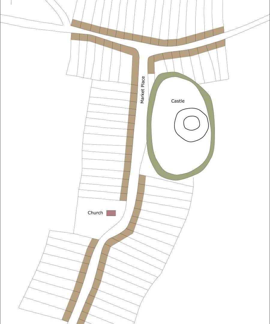
New Moat is now a small village with little to indicate its former status. There is no evidence that the settlement was ever defended. A north/south road meets an east/west road at a T-junction. The parish church of St Nicholas lies on the west side of the north/south road and the motte and bailey castle on the east side. The bailey of the castle is not easy to define on the ground, but a LiDAR image of the village clearly shows its extent with its northern side extending into gardens and paddocks.

Schematic plan of New Moat in c.1320 showing burgages and other features. It is highly unlikely that all the burgages were occupied at this time.
A series of low earthworks probably of abandoned burgages and house platforms have been noted in woodland immediately to the north of the church in Church Plantation. Two metre resolution LiDAR data hints at further house platforms/building plots on the opposite side of the road to the church, to the southeast.
The 1839 tithe map of New Moat depicts a very small village with a small cluster of buildings around the T-junction. There was little change between the tithe survey and the publication of the 1889 Ordnance Survey 1:2500 map in 1889. Indeed, almost all development in the village since the tithe survey occurred in the second half of the twentieth century. This development consists mainly of linear housing opposite the church, a small housing estate opposite the castle and modern farm buildings on the farm, Awel y Coed, to the south of the church.
Schematic plan of New Moat in c.1320 showing burgages and other features. It is highly unlikely that all the burgages were occupied at this time.
