
NEWCASTLE EMLYN
click here for a copy of the full report
SUMMARY
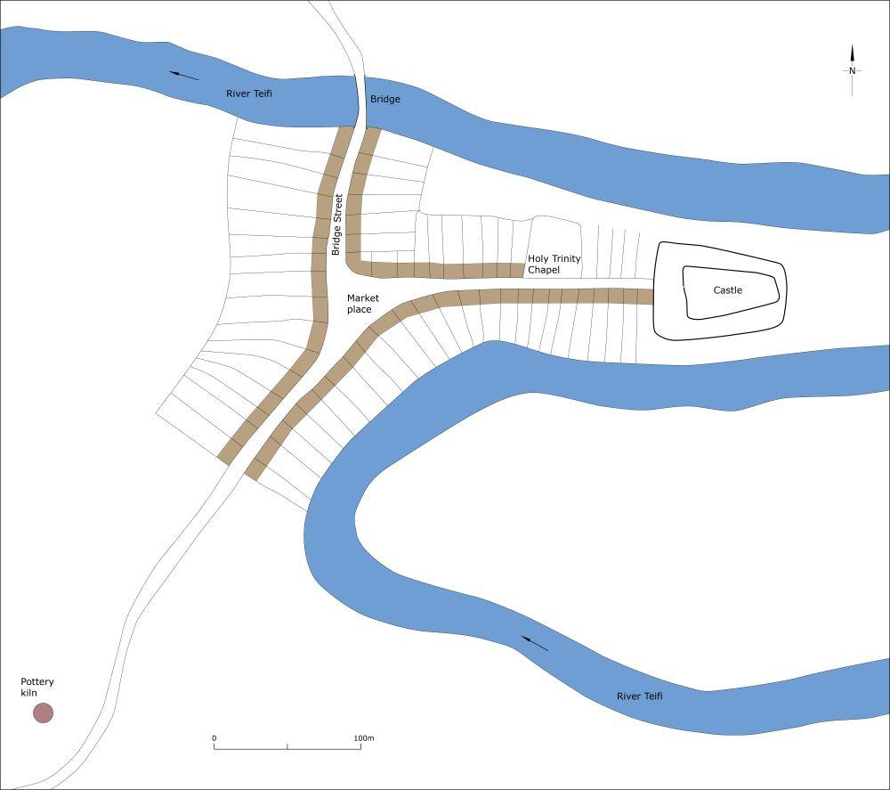
In 1240 a new castle was built at Emlyn in a crook of the River Teifi. A settlement developed outside the castle gates which was formalised as a borough in 1303 with a grant of a weekly market and two annual fairs. In 1316 62 burgages were recorded plus 24 other tenants. This seemed to be the high point of the medieval town as by the early fifteenth century just 30 burgesses were present. The medieval town consisted of three main streets, Castle Street, Bridge Street and Sycamore Street, which met at a triangular-shaped marketplace.
KEY FACTS
Status: Weekly market and two annual fairs. No town charter.
Size: 1316, 62 burgages plus 24 other tenants.
Archaeology: Burials and other remains revealed in excavations at Holy Trinity Chapel. A medieval pottery kiln investigated to the south of the town.
LOCATION
Newcastle Emlyn lies on the south bank of the River Teifi in Carmarthenshire (SN 310 407) on a narrow peninsular formed by an incised meander of the river. It lies on a bridging point of the Teifi. The medieval town of Adpar lies on the north bank in Ceredigion. The Teifi valley provides a good route-way, to Cardigan and the coast to the west and into the mid-Wales to the east. Roads lead over high ground south to Carmarthen and to the north to Aberystwyth and beyond.
HISTORY
In 1240 Maredudd ap Rhys built a new castle at Emlyn in Carmarthenshire in a crook of a pronounced meander of the River Teifi, named ‘new castle’ to distinguish it from the ‘old castle’ located at Cilgerran, although some authorities locate the ‘old castle’ at Cenarth. The new castle quickly became the administrative centre for the region. It is assumed that a settlement developed outside the castle gates, but even though the castle was attacked and changed hands three times in 1287 none of the historical sources mentions the existence of settlement. However, some authorities refer to the cluster of houses that developed outside the castle as ‘Trefcastell’. A bridge over the Teifi was in existence in 1257, linking Newcastle with the castle and settlement of Adpar on the north bank of the river in Ceredigion. In the late twelfth century Adpar was formalised as a town with weekly market and three annual fairs. Ninety-six burgesses were recorded there in 1326.
It was not until 1303 that a town called Newtown or Newtown of Emlyn (hereafter called Newcastle Emlyn) was founded. Twenty-six burgages were recorded in the following year. The new town rapidly expanded; 54 burgages were recorded in 1305, 61 in 1307 and 62 in 1316 plus 24 other tenants. Two annual fairs were established and a weekly market.
The town lay in Cenarth parish and thus did not have a church – the existing parish church of the Holy Trinity was built in 1842. However, a chapel of ease dedicated to the Holy Trinity lay outside the castle and is shown on the 1839 tithe map.
The early fourteenth century was a high point for the town. Like many towns in the region the European-wide population crash had a profound impact on Newcastle Emlyn and competition with Adpar on the opposite bank of the Teifi must have inhibited growth. In the early fifteenth century it is reported that the castle was in ruins and that revenues from the burgesses amounted to just 30s (at 12d per burgage this equates to 30 burgesses).
The later history of Newcastle Emlyn has not been researched, but it drifted into obscurity, it’s former status almost forgotten.
MORPHOLOGY
The castle occupies a naturally well-defended site within an incised meander of the River Teifi, some 10m above the river. Very little upstanding masonry survives. Earthworks associated with the castle include a ravelin erected during the English Civil War in the seventeenth century. The present castle grounds extent further to the west than the extent of the medieval castle – it is possible that the original settlement developed on what is now open ground immediately west of the upstanding medieval remains.

Schematic plan of Newcastle Emlyn as it may have been at its maximum extent in the medieval period, c.1320.
The approach to the castle is from the west, along Castle Street. The medieval Holy Trinity Chapel lay towards the east end of Castle Street outside the castle gates. At its east end, Castle Street has been widened to form a car park. On the south side of the street land falls steeply away to the river; land on the north side is level – a late twentieth century catholic church is located here. The tithe map shows the east end of Castle Street as open land apart from Holy Trinity Chapel. The west end of Castle Street is narrow and flanked by nineteenth century and later buildings. At its extreme west end the street opens out into a triangular-shaped marketplace, now occupied by a Victorian market hall, which replaced an earlier building.
A north/south street, the main road through the town, crosses the west side of the marketplace. To the north of the marketplace, it runs down to the bridge over the Teifi and hence is called Bridge Street; to the south it is now called Sycamore Street. An almost continuous façade of eighteenth, nineteenth and twentieth century buildings line these two streets. Church Lane runs to the west from the marketplace giving access to the nineteenth century Holy Trinity Church.
The regular, long narrow house plots on Church Street, Bridge Street and Sycamore Street indicate that they were laid out as burgage plots, probably when the borough was created in 1303.
Thomas Budgen’s map of 1811 shows buildings along both sides of Bridge Street, Sycamore Street and the west end of Castle Street, with a secondary centre around a turnpike road (now the A484) to the south. There had been little change by 1839 when the Cenarth parish tithe map was surveyed. New housing and other development did not occur on any great scale until the second half of the twentieth century.
There is no evidence that the medieval town was defended, but as previous writers have noted, it would have been a simple matter to have created a bank and ditch across the neck of the meander to protect the settlement around the castle.
