ST CLEARS
Click here for a copy of the full report
SUMMARY
The Anglo-Normans founded a castle at St Clears in the early twelfth century during their conquest of southwest Wales. A small settlement, protected by earth and timber defences, developed outside the castle gates. The settlement spread either side of the road running north towards the priory, which was also the parish church. A town charter was granted in 1393. The town remained small and from the mid-eighteenth century its focus shifted 1 km north from its medieval core. Small-scale investigations have demonstrated that medieval and later deposits survive in the core of the historic town.
KEY FACTS
Status: 1393 town charter.
Size: Unknown, but small.
Archaeology: An excavation and several smaller pieces of work have demonstrated the presence of medieval archaeological deposits.
LOCATION
St Clears lies in south Carmarthenshire (SN 281152) at the confluence of the Taf and Cynin rivers at their lowest bridging point. The rivers are tidal up to St Clears, although navigable only for small boats. The small town of Laugharne lies on the Taf 6 km downstream. The Taf, Towy and Gwendraeth rivers converge south of Laugharne forming a wide estuary. Carmarthen town lies on the Towy and Kidwelly on the Gwendraeth.
HISTORY
The town and castle of St Clears is poorly documented. In common with other locations in the region it is probable that a castle at St Clears was established during the Anglo-Norman conquest of southwest Wales in the early twelfth century. The first documentary reference to it is in 1153 when the Brut y Tywysogyon records ‘Rhys ap Gruffudd, and a large host with him, ravaged the castle of Ystrad Cyngen.’ Control of the castle then alternated between Welsh and English rulers until 1230 when it was granted to William Marshall the younger. The Marshalls were great castle builders and so it is probable that Marshall the younger converted the earth and timber castle to stone. It would seem that the castle fell into decay from the mid-to-late thirteenth century.
A Cluniac priory dedicated to St Clarus and Mary Magdalene was founded at St Clears between 1147 and 1184. The church functioned as both a priory and parish church. The priory was dissolved in about 1414. The extant church is mainly medieval with some nineteenth century restoration. It has been suggested that the dedication to St Clarus indicates an early medieval foundation.
The first mention of a town is in 1248, but it is likely that a settlement developed outside the gates of the castle soon after its foundation. A town charter was granted in 1393. The medieval and early modern history of St Clears has not been thoroughly researched, but it is known that it continued to function as a small port with ships docking at the quay close to the bridge well into the twentieth century. Shipping is one of the better documented aspects of medieval St Clears and records suggests a thriving port; in 1297 all St Clears ships of 40 ton and upwards were commanded to report to the king at Plymouth, and in 1326 ships of 50 ton and upward were commanded to report at Portsmouth to prepare for an attack on the French.
In 1763 the establishment of a turnpike trust to upgrade the road from Carmarthen to St Clears and on to Tavernspite shifted the focus of the town from its medieval core around the castle and church to a location c.1 km to the north. The opening of the railway between Carmarthen and Haverfordwest in 1854 pushed the town’s focus even further north away from its historic core.
MORPHOLOGY
Medieval St Clears lies in the crook of the confluence of the Taf and Cynin, with only the north and northwest sides of the town not bounded by water. Thus, although it is low-lying, it is a naturally well-defended location.

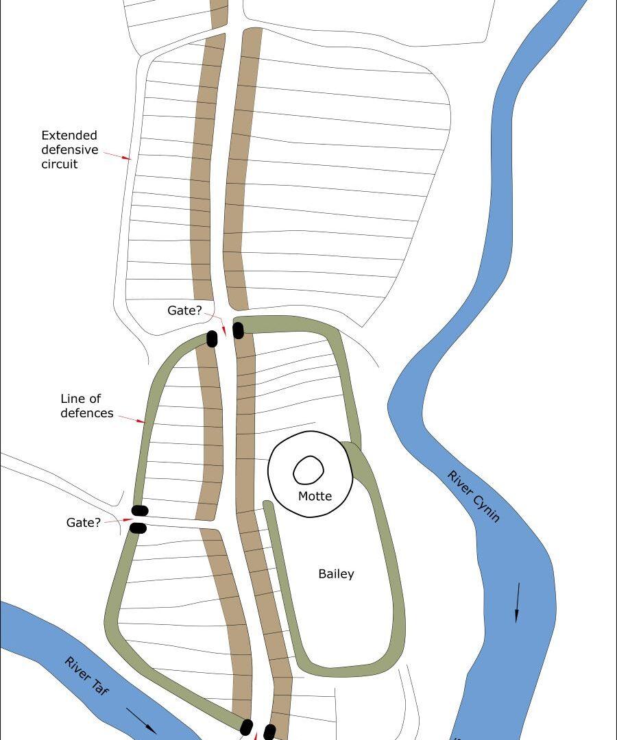
Conjectural plan of St Clears as it may have been at its maximum extent in the medieval period, c.1320.
The castle consists of a substantial motte with a bailey to its south. The bailey experienced clearance and levelling in the second half of the twentieth century; despite this a geophysical survey detected buried stone foundations. Stonework has also been noted on the motte.
This initial core of the town was very small, and although there is no documentary evidence for it having been defended morphology and topography indicates that it was; this has been proven by excavation. The line of the defences is well established on the west side of the town but less so on the north where there must have been a gate where the main road enters the town. The defensive line to the east and south is open to speculation – it may be here that the rivers formed the main defensive element. The morphology of the town suggests that the defended area of the town was extended at least once and possibly twice. Historic map evidence shows burgages on either side of the main north/south road through the town (Bridge Street and High Street). It is uncertain whether medieval development extended as far north as St Mary’s Church and beyond.
It is assumed that a bridge stood at its present location from the earliest years of the town as it is on the main route west from Carmarthen to Laugharne, Tenby and Pembroke.
St Mary’s Church (and medieval priory) lay to the north of the core of the medieval town, perhaps originally separated from it by undeveloped land. The claustral buildings lay to the south of the church.
As noted above the focus of the town moved to the north from at least the mid-eighteenth century. There is no evidence for medieval occupation in these northern areas.


