
ST DAVIDS
Click here for a copy of the full report
SUMMARY
The cathedral dominates St Davids. It is likely that a settlement developed in the early medieval period to serve the religious community, but its location and character is unknown. In 1115 St Davids was granted a town charter and by 1326 130 burgesses lived in the town. This was the high point of the town until its recovery in the nineteenth century.
KEY FACTS
Status: 1115 town charter, twice-weekly market, two annual fairs.
Size: 1326, 130 burgesses
Archaeology: No significant archaeological investigations.
LOCATION
St Davids lies in a relatively sheltered location in the west of Pembrokeshire (SM 753 253). It is a city, with the cathedral in its walled close in the valley of the River Alun and the streets and houses of the town to the south and east.
HISTORY
The history of the town (city as it now is) of St Davids is inextricably linked to the cathedral. A Christian community may have been established at St Davids as early as the sixth century. It is highly likely that a small civil settlement developed to support this early medieval Christian community, but the character and location of such a settlement is unknown.
During their conquest of southwest Wales in the late eleventh/early twelfth centuries the Anglo-Normans established a castle 300m to the west of the cathedral. There is no history attached to the castle, although some writers consider it was built by William the Conqueror when he visited in 1081.
In 1115 King Henry I of England granted a town charter to St Davids and in 1123 Pope Callixtus II declared that two pilgrimages to St Davids was equal to one to Rome. These two events undoubtedly resulted in the rapid commercial and administrative development of the town, although its population in the twelfth and thirteenth centuries is not recorded. In 1281, Bishop Bek granted the town the right to hold twice-weekly markets and two annual fairs. He also founded Whitewell Hospital to the south of the town. In 1326 130 burgesses are recorded, mostly Englishmen. Subdivision of burgages into half and quarter plots recorded at this time is evidence of a long established and prosperous town. This, however, was the high point of the medieval town, and in common with other communities across Europe it would have suffered population loss during mid-fourteenth century. The town remained in a decayed condition until fairly recent times – John Speed’s map of 1610 shows about 50 houses and he states St Davids had ‘few inhabitants’.
During the nineteenth century vacant plots were filled with new houses and in the twentieth and twenty-first centuries new houses and other buildings were constructed on the southern and eastern fringes of the historic core.
MORPHOLOGY

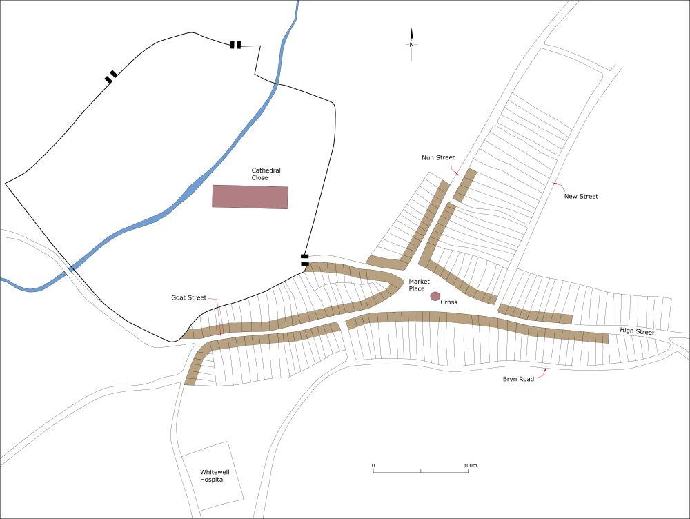
St Davids as it may have been at its maximum extent in the medieval period, c.1320.
St David’s Cathedral in its walled close occupies a sheltered location in the Alun valley. The town/city lies to the south and east of the valley on relatively flat ground. The town consisted of four main streets, Goat Street, Nun Street, High Street and Tower Hill, all of which converged on a triangular marketplace with its medieval city/market cross. Initially the town developed organically around Tower Hill and the north side of Goat Street. Analysis of the town’s plan reveals formal secondary development with burgages laid out in blocks along Nun Street and High Street, with Bryn Road and New Street forming back lanes to these plots. The triangular marketplace was probably laid out at the same time. Historic maps indicate that the marketplace was formerly wider and longer. This planned element of the town was certainly established by the early fourteenth century and probably by the end of the twelfth/early thirteenth century.
Despite the depopulation of the town in the fourteenth century the pattern of burgages persisted for several centuries and was depicted on nineteenth century maps. The 130 burgesses recorded in 1326, which roughly equates to 130 burgages, could easily be accommodated in the four streets mentioned above.
There is no indication that the town was ever provided with defences.
