
TEMPLETON
Click here for a copy of the full report
SUMMARY
Templeton is a planned village, planted in the eleventh or twelfth centuries soon after the Anglo-Norman conquest of southwest Wales. It was never a town. The original village consisted of houses on long, narrow plots on the west side of a main north/south road. At an unknown time houses were built on the east side of the road. It remained small with many vacant plots until the mid/late twentieth century when new houses began to be built. Small-scale archaeological investigations have demonstrated that significant medieval and later archaeological deposits survive on undeveloped plots.
KEY FACTS
Status: Not a town.
Size: Unknown. In 1532 16 freeholders and three leaseholders were recorded.
Archaeology: Archaeological investigations have revealed medieval deposits.
LOCATION
Templeton is a linear village in inland Pembrokeshire straddling the main north/south A478 Tenby to Cardigan road (SN 113 115). The A4115 runs to the west from the village and the B4315 to the east. Narberth lies 3 km to the north and Tenby 11 km to the south. It lies at 120m above sea level in a pastoral-dominated agricultural landscape.
HISTORY
Templeton is thought to derive its name from ‘the farm (tun) of the Templars’. By tradition a religious house of the Order of the Templars stood at Templeton, but apart from the place-name there is no evidence to support this. The Order was dissolved in the early fourteenth century and the Knight’s Hospitallers of St John took over many of their possessions. The Hospitallers had a commandery at Slebech, 10 km to the west, but there is no evidence that they ever held land at Templeton.
It was never a town, although some authorities include Templeton in their lists of towns; it did not have a charter, a market or a fair. It is, however, a good example of a medieval planned village.
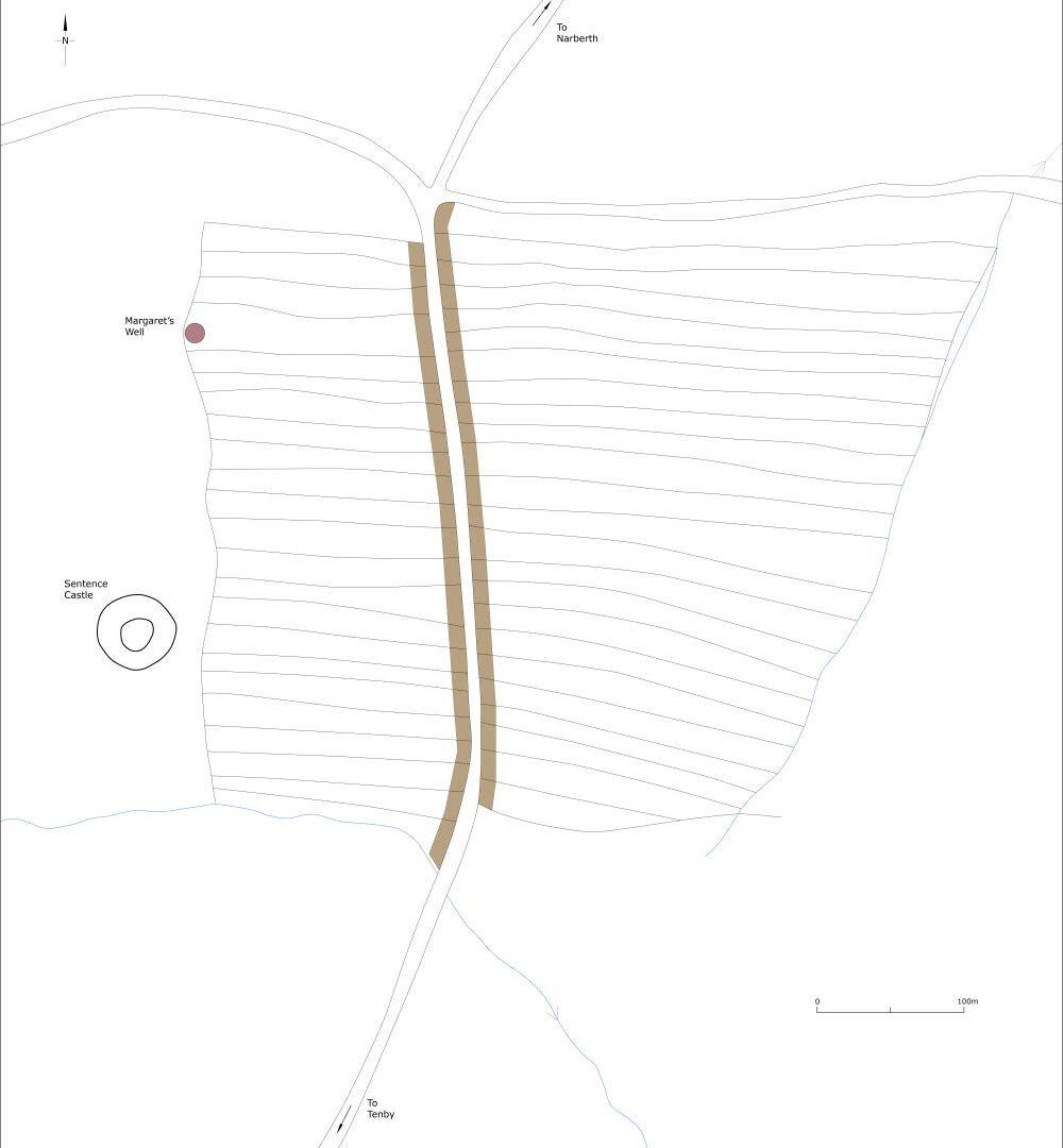
The earthen Sentence Castle, immediately to the west of the village, is the earliest element of Templeton. The date of its foundation is unknown, but its ringwork form suggests it was constructed in the twelfth century. In 1282 Templeton was known as Villa Templarii (village of the Templars). A year later the name had become Villa Templariorum Campestris (village of the Templars in the fields) and in the same year ‘burgesses of the wind’ (de vento) are recorded each paying the standard 12d a year. Also, in the late thirteenth century Sarah and Walter le Cole acquired two adjacent plots, which perhaps can be interpreted as amalgamation of house plots and that decline had already set in. It is assumed that along with other settlements in southwest Wales Templeton’s population declined as the Black Death swept across Europe in the mid-fourteenth century.

Conjectural layout of Templeton, c.1320.
Surveys made in 1532 and 1609 both record 16 freeholders and three leaseholders in Templeton, with one freeholder holding two plots, giving a total of 20 plots. The earliest large-scale map of the village made in 1829 shows a linear village with buildings on both sides of main north/south road. Later nineteenth-century Ordnance Survey maps show a similar pattern. Indeed, the layout was unchanged until the second half of the twentieth century when new houses appeared within and on the outskirts of the village.
St John’s Church on the southeast end of the village was built in 1859. There is no evidence to support the tradition that it was built on the site of a Knights Templar building, although the site had been used previously as a Unitarian meeting house. A medieval cross in the churchyard was relocated from its original site elsewhere in the village.
MORPHOLOGY
Templeton is a linear village straddling the main north/south A478 Tenby to Cardigan road. It has been argued that the first phase of the village consisted of a series of 170m-long plots laid out on the west side of the road defined by a large boundary bank on their western side separating the plots from Sentence Castle. The 1889 Ordnance Survey map shows the basic plan of these plots allowing for amalgamation since the thirteenth century. Plots and houses on the east side of the road being a second phase. It is uncertain when houses were built on the east side of the road, but an 1829 map shows houses on both side of the road.
Templeton has experienced a considerable amount of housing development since the mid/late twentieth century, including the construction of individual houses and small estates both within the village’s historic core and on its periphery.
