
WISTON
Click here for a copy of the full report
SUMMARY
Wizo founded Wiston, one of many settlements created by Fleming colonists in the early twelfth century in Pembrokeshire. A church and castle were built and a settlement laid out. Wiston was initially successful, but during the fourteenth century, perhaps earlier, it went into decline and by the later medieval period it was little more than a village, a form it retains to the present day. Investigations have demonstrated the high potential for archaeological remains dating to the twelfth century and later to survive in all undeveloped areas of the former town.
KEY FACTS
Status: Not a town.
Size: Unknown.
Archaeology: Several archaeological investigations have revealed medieval deposits.
LOCATION
Wiston lies on a rounded ridge in central Pembrokshire (SN 022 181) at a height of about 110m in an agricultural landscape dominated by improved pasture, with a little arable land. Haverfordwest lies 7 km to the southwest and Narberth 9 km to the southeast. Llawhaden, formerly a small town lies on the ridge 4 km to the east.
HISTORY
In the late first century AD the Romans established a fort at Wiston 500m to the north of the current village. A civil settlement developed to the south of the fort and continued in existence until the fourth century, long after the military had left. There is no known settlement in the area between the fourth century and the twelfth century.
It is from the Fleming Wizo that Wiston takes its name. Wizo arrived in southwest Wales a little before AD 1112 following the Anglo-Norman military conquest. Flemings served as mercenaries in the conquest, but Wizo came with a group of settlers intent on colonising the region. A castle and church were established at Wiston, but it is not until 1147 that there is a direct documentary reference to Wiston when the castle was taken by Hywel ab Owain. For the rest of the twelfth century and into the thirteenth century the settlers and the disposed Welsh disputed the territory with the castle regularly changing hands. In 1220 Llywelyn ap Iorwerth destroyed the castle and burnt the town – this is the first specific mention of the town. It is likely that the castle was not repaired following this attack; a new castle was built at Picton 5 km to the south.
There is virtually no documentary evidence for the town of Wiston, reflecting its decline in the later medieval period and modern times. That Wiston ever had borough status has been disputed (no charter has been identified), however an annual fair and a weekly market were held up to about 1600 and from the scant documentary sources available it is clear that the inhabitants considered that it had borough status; they continued to elect a mayor into the twentieth century. It is not clear when the population of Wiston declined, but the burning of the town in 1220 and the subsequent relocation of the castle to Picton may have been the trigger. It is likely that following the European-wide population crash in the mid-fourteenth century Wiston was little more than a church, a ruined castle and a few houses.
MORPHOLOGY
Wiston can now hardly be called a village, it is little more than a collection of dispersed houses, a medieval church, a motte and bailey castle, and a modern school.

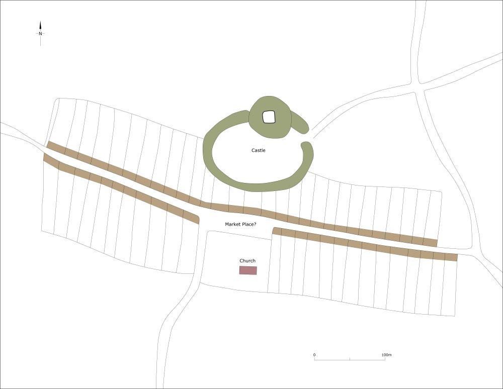
Schematic plan showing a suggested layout of of Wiston at its maximum extent in the thirteenth/fourteenth century.
Wiston Castle is the best example of a motte and bailey castle in southwest Wales. A substantial motte crowed by a polygonal stone-built keep dominates a large bailey to the south. The bailey, defended by a bank and ditch, may be a reused Iron Age defended enclosure (of which there are many examples in the region) and is sufficiently large enough to have accommodated the houses of Wizo’s first wave of settlers. The Manor House, probably originally an Elizabethan structure but now reduced to the service wing, stands on the Green, an open space to the east of the castle.
St Mary’s Church lies to the south of the castle. Apart from the church and the Manor House other buildings are few and dispersed and date to the nineteenth and twentieth centuries. Development in the latter part of the twentieth century includes a school immediately to the west of the castle and a few dispersed houses. Earthworks in Church Field, immediately to the north of the church, on the Green and to the south of the Green on the opposite side of the road are the remains of the sites of houses and burgages
It has been suggested the castle and church formed the core of medieval Wiston and that burgages were laid out alongside the road running south from the west side of the church and alongside a parallel road 300m to the east (this is now a footpath). However, large-scale geophysical work failed to detect any evidence for burgages in these areas. A more likely layout of Wiston as it may have been in the twelfth and thirteenth centuries and based on historical, topographic and archaeological evidence is shown in the accompanying illustration.
