
KIDWELLY
Click here for a copy of the full report
SUMMARY
Following the Anglo-Norman conquest of southwest Wales, Henry I installed the Bishop of Salisbury as lord of Kidwelly. He founded Kidwelly castle and defended town on the north side of the Gwendraeth Fach river and a priory on the south side during the first two decades of the twelfth century. The town rapidly expanded and by the fourteenth century had spread along several streets outside the town defences. Within the defences burgage plots became vacant and have been since the medieval period. The priory, on the south side of the river, provided a secondary focus and here a settlement developed from at least the fourteenth century. Archaeological investigations within the defended town have revealed the presence of medieval and later stratified deposits.
KEY FACTS
Status: 1107-14 town charter.
Size: Uncertain. 136 burgages in early sixteenth century.
Archaeology: Stratified medieval deposits survive in the old town.
LOCATION
Kidwelly lies on the Gwendraeth Fach over one kilometre from where it flows into Carmarthen Bay (SN 408 070). The river is tidal to just upstream of Kidwelly, but it is now silted up and is not navigable. Kidwelly Castle and the ‘old’ town lie in a slightly elevated position on the north bank of the river. St Mary’s Church and the ‘new’ town lie on lower-lying ground to the south of the river.
HISTORY
Following the Anglo-Norman conquest of South Wales Henry I installed Roger, Bishop of Salisbury, as lord of Kidwelly in 1106. He started building the castle soon after this date. English, French (Norman) and Flemish settlers would have been housed close to the castle. Between 1107 and 1114 a charter was granted to the town and Kidwelly Priory was established. Thus three elements of Anglo-Norman colonisation – castle, town, and monastery – were in place by the early twelfth century. The town occupied a defended area to the south of the castle with the priory on the south side of the River Gwendraeth Fach. The castle remained in Anglo-Norman (English) hands for much of the twelfth and thirteenth centuries apart from short periods when it was captured by Welsh rulers. The growth of the town was disrupted by attacks in 1215 and in 1231; in the war of 1258 the town was destroyed. By the late thirteenth century Kidwelly was in the hands of the Chaworth family and it is they who constructed much of the stone castle that survives to this day. Later additions include the fine gatehouse. The castle continued to be used and minor repairs are recorded throughout the sixteenth century, but in 1609 it is recorded as ‘greately decayed and ruynated’.
In 1280 the townspeople were granted a licence to enclose the town with walls, probably replacing existing earth and timber defences. The walls and gates had been built before 1332. By the fourteenth century the old town of Kidwelly had spread outside the narrow confines of the walled area, along what are now known as Ferry Road, Water Street and Bridge Street. This seems to have been at the expense of the settlement within the walls as deserted burgages were recorded in 1401.
Outside the old town a small settlement of tenants of the prior developed around the priory. These did not attain the privileges of self-government enjoyed by the burgesses of the old town, and the settlement was not defended by a rampart or wall. During the fourteenth century the priory church was rebuilt as the parish church of St Mary.
The castle and town came under sustained attack during the Glyn Dŵr rising of 1403-04 during which it was destroyed. The defences of the castle and town were strengthened following the rising, but the ‘old’ town did not recover from the attack. The 1444 town charter describes the old town as ‘now in manner waste and desolate for want of Burgesses there dwelling’ and in the 1530s John Leland noted that the old town ‘is nere all desolated’.
An early sixteenth century survey records about 136 burgages, mostly along Ferry Road, Water Street and Bridge Street, with just three burgages, seven tenements and eight cottages within the town walls. South of the bridge eight burgages lay on ‘Le Cawsey’ and three on St Mary’s Street. Twenty-eight other dwellings were recorded on St Mary’s Street.
The shift of the focus of the town first to the streets outside the walls of the old town and later to the new town south of the river is confirmed in a deed of 1574 when the existence of a civic hall at its present location is mentioned.
There seems to have been little expansion of the town in the seventeenth and eighteenth centuries, with new development accompanying modest industrial development in the nineteenth and twentieth centuries.
MORPHOLOGY
Kidwelly can be treated as two separate entities; the castle and ‘old’ town on the north side of the Gwendraeth Fach and the parish church and ‘new’ town on the south side.

Conjectural plan of Kidwelly c.1150.
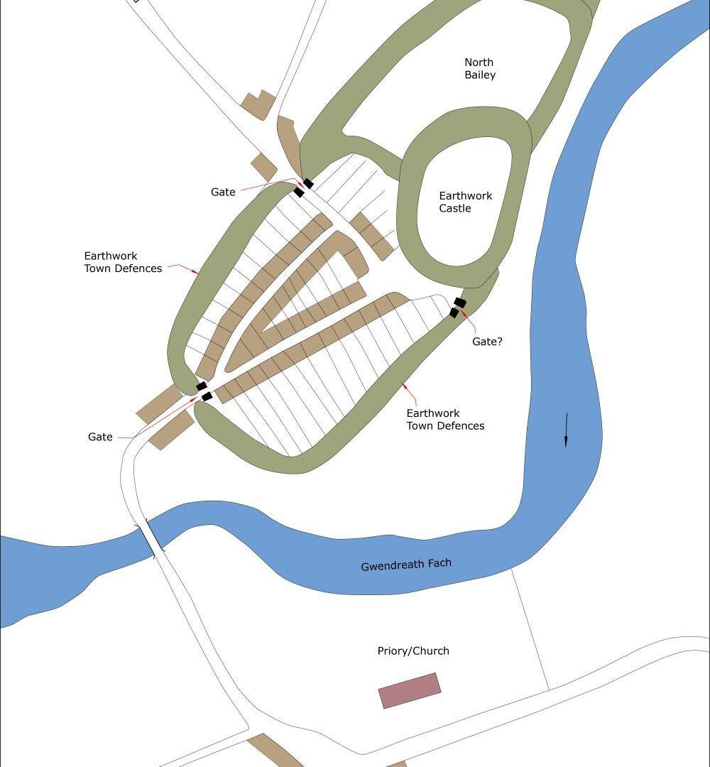
The stone-built castle sits within a substantial earthwork enclosure. The northern part of this enclosure is referred to here as the North Bailey and is devoid of buildings; the walled ‘old’ town lies in the southern part of the enclosure. The North Bailey is divided into two, separated by a substantial ditch, which documents indicate was dug during the Glyn Dŵr rising of 1403-04. However, there is no evidence that the North Bailey was ever built on – although it may have been planned to accommodate part of the town – and indeed as early as the late thirteenth century and fourteenth century documents refer to gardens and a dovecote which may have occupied these two enclosures. Later, ‘Two Conigars’ (rabbit warrens) are referred to in this area.

Plan of Kidwelly as it may have been at its maximum extent in the medieval period, c.1320.
The southern enclosure, by contrast, encompassed the ‘old’ town and seems to have done so since the foundation of castle in the early twelfth century. The line of the town walls is well attested. The wall on the southeast side of the town survives; the projected line of the wall on the north side of the town is defined by topography and a length of wall survives on the north edge of the town, terminating on the edge of the castle ditch. A small excavation here in 1980 showed the wall to be sitting on an earthwork bank.
Documents record either two or three gates to the town. The main gatehouse, dating mainly to the fourteenth century, still stands on the southwest side of the town. A second gate would have stood at the end of Castle Road – the north gate. It has been argued that an extant archway was the site of a medieval gate, but this is more likely to be later in date, created when the North Bailey was used as rabbit warrens. The third gate, if it ever existed, is likely to have been close to the castle gatehouse, giving access to the mill and river.
As noted above, the town within the walls seems to have been largely deserted from at least the fifteenth century. It is possible that originally the parish church stood in the ‘old’ town and that the designation of St Mary’s Church on the south side of the river as the parish church in the fourteenth century reflected the shifting focus of the town. Today the old town contains a series of dispersed buildings dating to the nineteenth century and later, with perhaps earlier elements in some of the structures. There is a lot of open space and no clear pattern of surviving medieval burgages.
It is clear from documentary evidence that in the medieval period the town expanded outside the defences surrounding the ‘old’ town. Burgages in the form of long, narrow properties are still evident on maps and on the ground on Water Street, Ferry Road, New Street and Bridge Street, perhaps laid out as early as the thirteenth century. Particularly good examples survive on the south side of Water Street. The street frontages present an almost unbroken façade of terraced houses of nineteenth and later date, with one or two building perhaps of eighteenth-century date.
What are almost certainly burgages are also preserved in the modern townscape to the south of the river, along Bridge Street, Causeway Street, Pinged Hill and Lady Street, focused on the junction of Lady Street and Causeway/Bridge Street adjacent to the St Mary’s Church and the town hall. Street frontages are of almost unbroken terraces, with domestic and commercial properties interspersed. Buildings are nineteenth century or later.
St Mary’s Parish Church/St Mary’s Priory lies at the heart of the ‘new’ town. The extant church is a substantial building of cruciform plan, comprising a chancel, nave, vestry, north and south transepts and tower. The church was originally part of the priory. Apart from the church, nothing of the Benedictine priory survives above ground. The location of the claustral and other building associated with the priory is uncertain; the Ordnance Survey 1:2500 1st Edition map labels ‘Priory (remains of)’ to the north north-east of the church; it has been suggested that the priory lay to the east end of the current church, whilst to the west a building known as ‘Prior’s House’ stood to the west of the church.
Castle Mill is an early nineteenth century building, but is assumed to be located on and earlier mill site, perhaps originally medieval.
