
ADPAR
Click here for a copy of the full report
SUMMARY
The Anglo-Normans built a motte and bailey castle at Adpar on the north bank of the River Teifi in the early twelfth century and a settlement soon developed around it. In the late thirteenth century, the settlement was organised along burghal lines with a weekly market and three annual fairs. In 1326, 96 burgesses were recorded. Adpar rapidly declined and was nothing more than a village by the end of the medieval period. Nothing survives to indicate its former importance.
KEY FACTS
Status: weekly market and three annual fairs.
Size: 1326 96 burgesses.
Archaeology: Features associated with the castle recorded in an evaluation.
LOCATION
Adpar lies on the north bank of the River Teifi in Ceredigion (SN 309 409). Newcastle Emlyn occupies the south bank in Carmarthenshire. The Teifi valley provides a good route-way, to Cardigan and the coast to the west and into mid-Wales to the east. Roads lead over high ground to the south to Carmarthen and to the north to Aberystwyth and beyond.
HISTORY
The Anglo-Normans were probably responsible for building a motte and bailey castle on the north bank of the River Teifi at Adpar (called Atpar in some historic documents) during their brief occupation of Ceredigion in the early twelfth century. There is no history associated with the castle. It is likely a settlement developed organically outside the castle during the twelfth and thirteenth centuries. The later history of Adpar is bound with that of Newcastle Emlyn on the south bank of the river where a castle was founded in c.1240 and a town in 1303. A bridge across the Teifi between Adpar and Newcastle Emlyn was in existence by 1257.
Adpar was a possession of the Bishop of St Davids and in the late thirteenth century Bishop Bek reorganised an existing Welsh settlement on burghal tenure lines: the names of early burgesses were predominantly Welsh. Adpar was granted the right to hold a weekly market and three annual fairs. In 1326 96 burgesses were recorded, a substantial town for the period. One individual, Griffith Vachuan, held numerous burgages, several individuals held burgages in both Adpar and Newcastle Emlyn and 15½ burgages were in the bishops’ hands for lack of tenants -Adpar was not thriving.
There is no record of a church at Adpar (it was formerly in the parish of Llandisiliogogo, but by the nineteenth century it was in the parish of Llandyfriog), although priests are recorded ministering to the burgess, which may be an indication of at least a chapel in the town.
The later medieval history of Adpar has not been researched; little documentary evidence survives as much was lost in a fire of 1752. The European-wide population crash of the mid-fourteenth century and the foundation of Newcastle Emlyn on the opposite bank of the Teifi must have had an impact on Adpar’s development. It is probable that in the later medieval period Adpar had effectively ceased to function as a town, as in 1536 properties in Adpar were in the hands of a few small estates. A drawing made during the first Duke of Beaufort’s tour through Wales in 1684 clearly shows Adpar motte, the bridge over the Teifi and Newcastle Emlyn castle, with tents pitched in what would have been the former town. Only one small building is shown. In 1741 it was stripped of its borough status (although it never seems to have been awarded a charter).
MORPHOLOGY
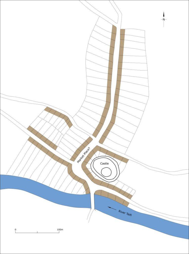
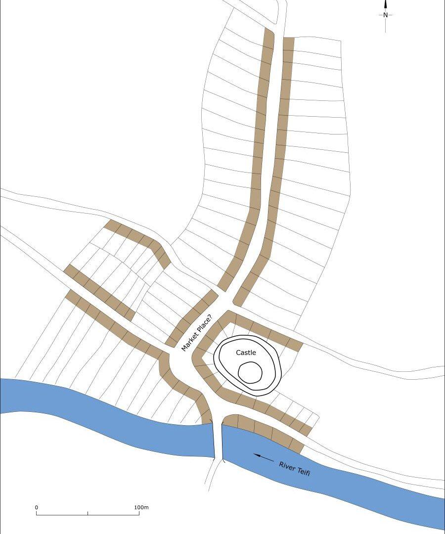
Map showing Adpar as it may have been at its maximum extent in the medieval period, c.1320.
There is nothing now to indicate the former importance of Adpar. Apart from the motte no medieval elements are detectable in what is now a village with much modern housing to the north and the northwest. The main road through the village, the B4571, runs from the bridge over the Teifi to the north up a fairly steep valley side. The A475, which runs from the east alongside the river to the bridge, was constructed after 1844 as it is not shown on the parish tithe map. The road running west from the bridge, the B4333, along Lloyd Terrace, may also be a recent routeway, as an 1811 map by Thomas Budgen in the British Library depicts it as a cul-de-sac. The original east/west route through Adpar is shown on the tithe map with a crossroad in the centre of the settlement.
The medieval motte lies on the east side of the north/south road through the village, 60m to the north of the bridge. Evidence revealed in an archaeological evaluation suggests a bailey may have been located to the north of the motte. The long narrow properties on both sides of Lloyd Terrace shown on the 1889 Ordnance Survey map led some writers to believe these were medieval burgage plots, but an examination of the earlier maps shows they were laid out in the mid-nineteenth century. The location of the properties held by the 96 burgesses in 1326 is unclear, but it is most likely that they clustered around the bridgehead and on both sides of the north/south road and alongside minor roads.
