
HAVERFORDWEST
Click here for a copy of the full report
SUMMARY
In the early twelfth century a town, known as Castleton, developed on the hilltop outside the newly founded Haverfordwest Castle. A marketplace and a church, St Martin’s, were provided for the economic and spiritual well-being of the inhabitants and defences for security. The town rapidly outgrew its hilltop location and two new churches were founded to the south of Castleton. By the late thirteenth century Haverfordwest was one of the largest towns in Wales. Archaeological investigations have been small-scale but have demonstrated that stratified medieval and later deposits are likely to be encountered almost anywhere in the historic core of the town.
KEY FACTS
Status: 1213 town charter. Weekly market and annual fair.
Size: 1376 422 burgages.
Archaeology: Small-scale excavations revealed stratified medieval deposits.
LOCATION
Although Haverfordwest is almost 30km from the open sea the river on which is lies, the Western Cleddau, is tidal. The town is located in the rich agricultural land of central Pembrokeshire (SM 953 157) on what was until the mid-twentieth century the lowest bridging point of the river.
HISTORY
Tancred, a Flemish settler, is credited with having founded Haverfordwest Castle between 1108 and 1113 during the Anglo-Norman conquest of southwest Wales. The early history of Haverfordwest is not well documented, but a settlement, known as Castleton, soon developed outside the castle gates, probably populated mainly by Flemish immigrants. The earliest direct reference to the castle and town is in 1152-76. Burgages are recorded at this date and a market had been established. A market cross is mentioned, presumably located in what is now Queen’s Square, with St Martin’s Church on the west side of the square.
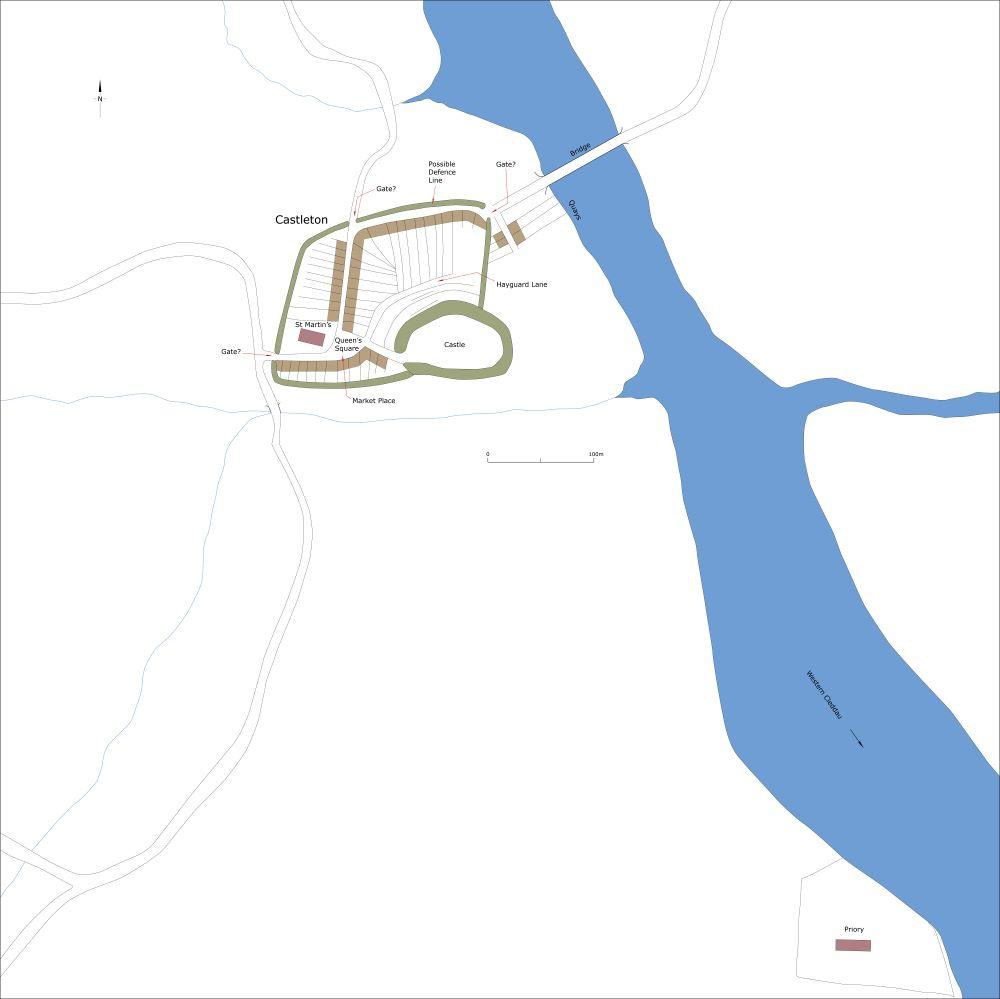
Conjectural plan of Haverfordwest c.1150.
Haverfordwest was attacked by the Welsh in 1115, 1136, 1147, 1189 and 1193, but the castle and lordship remained in the hands of Tancred’s family throughout the twelfth century. In about 1200 Robert fitz Richard, Tancred’s grandson, granted a plot of land 600m downstream of the castle to the Augustinian canons to build a priory. He endowed the town with two additional churches, St Mary’s and St Thomas a Becket. St Martin’s was then in existence, but St Mary’s and St Thomas’s may not then have been built and were part of Robert’s ambitious plans for the expansion of Haverfordwest. Both lay some distance from Castleton. In 1207 Robert was granted the right to hold a Sunday market and annual fair in the town.
In 1210 King John dispossessed Robert fitz Richard of all his holdings and in 1213 Haverfordwest was granted to William Marshall, Earl of Pembroke. Marshall’s charter issued soon after 1213 granted favourable privileges to Haverfordwest which in part explains the rapid growth of the town during the thirteenth century. A second charter of 1219-29 may have been issued to promote growth following the burning of the town ‘up to the gate of the castle’ during Llewellyn Mawr’s attack of 1220. In 1263 the burgesses of the town were granted the right to levy ‘murage’ – that is to raise funds for the building of town walls. Castleton had already been provided with defences, so these funds were either to convert Castleton’s existing earth and timber defences to stone or more likely to protect the rapidly expanding town. Later maps and documents show and refer to town gates to the south and west of the expanding town.
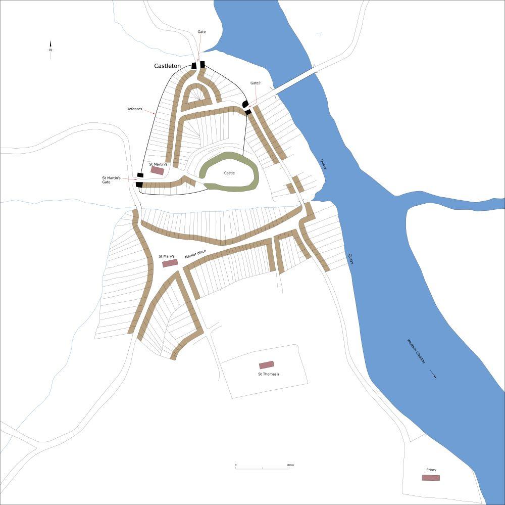
Conjectural plan of Haverfordwest c.1250.
The demand for housing quickly outstripped supply, evidenced in the 1280s when the sub-division of burgages into half plots and quarter plots was recorded. The exact population of the town at this time is not known, but it has been suggested that Roger Mortimer’s 1282 one third interest in the burgage rents of the town amounted to £6 10s. Multiplied by three gives a total rent from burgages of £19 10s, which with an annual rent for a single burgage of 12d equates to 390 burgage plots, making Haverfordwest one of the largest towns in Wales in the late thirteenth century, although this number of burgages may be an over estimation. There may have been as many as 360 burgages in 1326 and 422 by 1376. These figures suggest that Haverfordwest avoided, or recovered very quickly from, the mid-fourteenth century European-wide population crash that affected so many towns. However, these figures may be misleading as the number of burgages, are not always a true reflection of population size – the number of burgages recorded in the fourteenth century may include vacant plots, as a 1473-4 survey records vacant 120 burgages.
During the thirteenth century, the focus of the town shifted from Castleton to High Street and a new marketplace around St Mary’s Church – a guildhall is referred to here in late thirteenth-century documents. Development had also spread along Bridge Street, Ship Street (Quay Street), Market Street, Goat Street, Hill Street and Dew Street. Indeed, in 1473-4 thirty-two of Castleton’s burgage plots were vacant. In 1596 further plots were vacant.
In addition to the Augustinian Priory located downstream of the town, the Dominicans (Black Friars) founded a second monastic house, a friary, in the town sometime before 1246. Initially this was in an unfavourable position, but in 1256 the friars were granted funds to relocate their church and other buildings. The exact position of the relocated friary is unknown as nothing now remains above ground, but it was on the east side of Bridge Street, probably between the lanes called Hole in the Wall and The Friars. It was a large community with 39 friars recorded in 1285. It continued to expand and in 1285 the friars acquired more burgages; the friary may eventually have occupied the whole of the east side of Bridge Street with a chapel dedicated to the Holy Trinity close by what is now the Old Bridge.
Haverfordwest was an important port with quays alongside the western bank of the Western Cleddau downstream from what is now the Old Bridge towards the Priory.
If Haverfordwest experienced population decline in the mid-fourteenth century it had recovered by the mid-sixteenth century when in 1547 it was described as ‘the best buylt the most civill and quickest occupied Town in South Wales’.
MORPHOLOGY
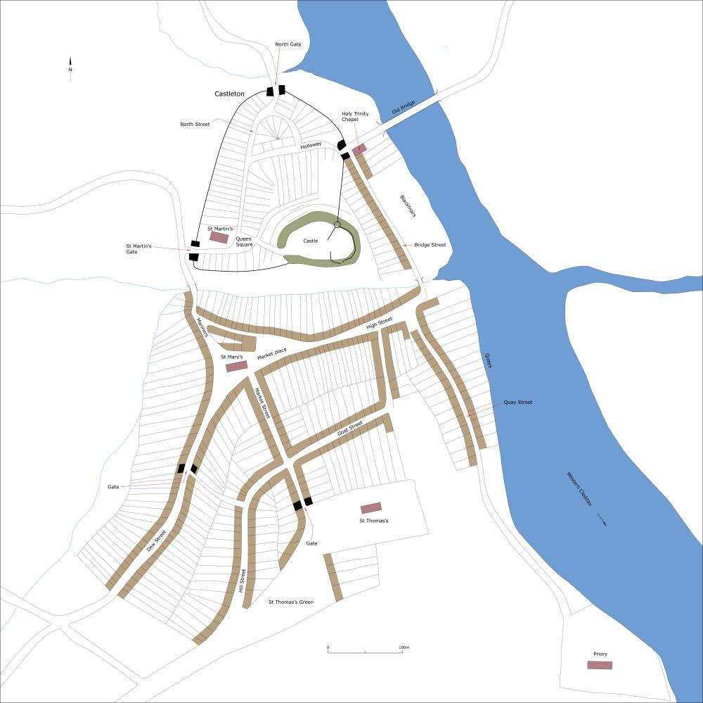
Conjectural plan of Haverfordwest c.1320.
The castle and early town – Castleton – occupy a rocky hill overlooking the Western Cleddau. Land falls away precipitously to the east to the river, steeply to the north and south and more gently to the west. High Street and St Mary’s Church lie to the south of the castle and the early town on the opposite side of a minor valley the bottom of which is now occupied by a car park called Castle Lakes, but formerly a stream called Schytericheslake (translated as Shitter’s Brook, indicating it was an open sewer) in later medieval documents, which flowed down into the Western Cleddau.
Castleton exhibits no evidence of formal planning. It consists of several streets to the west and north of the castle (North Street, Church Street, Holloway, Hayguard Lane), St Martin’s Church and a marketplace (probably in what is now Queen’s Square). Later expansion of Castleton included the north end of North Street and Kiln Road – the whole of Castleton was provided with defences, probably at first earth and timber, later rebuilt in stone. The exact line of the defences is unclear apart from along the west side of Castleton where extant property boundaries almost certainly mark its course. There were probably three gates into Castleton. North Gate survived until the late seventeenth century and is marked on Lea’s 1690 map of Haverfordwest. A second gate lay on Church Street close to St Martin’s and a third probably at the end of Holloway, giving access to quays and the bridge over the river. Castleton rapidly outgrew the confines of its defensive circuit. Houses were built around what is now Perrot Avenue and Mariner’s Square to the southwest, and also close to the bridge.
In the early thirteenth century as part of Robert fitz Richard’s expansionist plans St Mary’s Church was founded, burgage plots were laid out on either side of High Street and a marketplace established in the triangular plot of land occupied by the new church. At the same time, or not long after, burgage plots were laid out alongside Market Street, Goat Street, Bridge Street and Quay Street. St Thomas a Becket’s Church was probably also established at this time on open ground to the south, with an area set aside for the annual fair (now St Thomas Green). A priory was founded to the south of the town. It is likely that this new development was at the expense of Castleton, which may have become a bit of a backwater.
This expanded town was provided with defences. The course of these and the exact location of the gates in not known, but West Gate stood at the top end of High Street to the south of St Mary’s Church, probably where the street narrows, and South Gate would have stood on Market Street. Thomas a Becket Church would have stood outside the town walls.
Before the end of the thirteenth century burgage plots had been laid out outside the town walls on Dew Street, Hill Street and elsewhere. It has been noted that the reverse S-shape of the plots on Dew Street indicates that they were laid out over former open fields. A Dominican Friary was established on level ground alongside the river on Bridge Street in the mid-thirteenth century on what had been burgages. There is now no trace of the Friary and Bridge Street is occupied by shops and other commercial premises.
The exact location of the town quays and wharfs in the medieval period has not been established. Nathaniel and Samuel Buck’s 1748 ‘East View of Haverford-West in the County of Pembroke’ shows the warehouses and other buildings fronting the river from the Old Bridge down to the Priory. In the medieval period, and indeed until the early nineteenth century, the river to the east of the town would have opened out into a wide tidal lagoon with the Old Bridge approached from the east via a causeway. This was before the construction of the second bridge over the river at the foot of High Street.
Haverfordwest achieved its medieval apogee in the early fourteenth century, after which it experienced modest decline, picking up again later in the medieval period. Since then the town has experienced considerable growth, particularly from the mid-nineteenth century.
