

Introduction
The Iron Age of southwest Wales is characterised by defended enclosures. These settlements range from large hillforts surrounded by substantial banks and ditches down to lightly defended enclosures of less than 0.3 ha. A pan-Wales study by the Gwynedd Archaeological Trust in 2003-04 identified 613 defended enclosures in southwest Wales of which 235 are Scheduled Ancient Monuments. Five hundred and twelve are upstanding earthworks, 68 are crop-marks, 30 are recorded only by place-names or documentary sources and three are unspecified. The current condition of many of the unscheduled sites is not known as most have not been inspected by an archaeologist for over 30 years. Sites discovered by aerial photography have only rarely been inspected on the ground. This pan-Wales project is therefore an opportunity to examine, characterise and assess this important class of prehistoric monument.
April 2004 – March 2005
Dyfed Archaeological Trust’s 2004-05 study was desk-based, covering the counties of Carmarthenshire, Ceredigion and Pembrokeshire. It identified 1079 certain and possible prehistoric defended enclosures in the three counties. This total included 164 sites known only as place-names and which have no known physical presence. The remaining 915 sites comprised mainly upstanding earthwork hillforts and defended enclosures, and cropmarked enclosures. 215 of these sites are Scheduled Ancient Monuments.
During the course of the study 201 new site records were created. The information for these new records came from two main sources: a now obsolete GIS system compiled by Dyfed Archaeological Trust on behalf of the RCAHMW in 1996-97, and records created by the RCAHMW over the past few years, mainly as a result of aerial photography carried out by Toby Driver. Information gathered during the study has been added to the Regional Historic Environment Record.
In future years site visits will be undertaken. The overall aims are: application of definition, classification, quantification and distribution of defended enclosures; assessment of the archaeological significance of these sites; assessment of the vulnerability of these sites and a review of scheduling criteria/management strategies; enhancement of the HER/END.
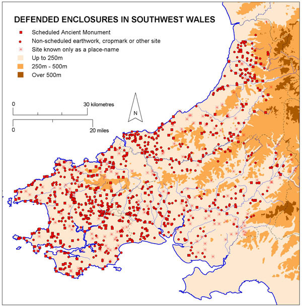
Map showing distribution of all defended enclosures/hillforts in southwest Wales
Prehistoric Defended Enclosures Report in full in PDF format – 1.6Mb (opens in a new window)
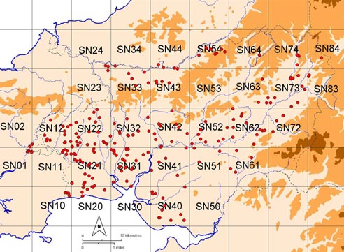
2005-2006 – A Survey of Defended Enclosures in Ceredigion

Members of the Defended Enclosures Project working group on a field visit to a hillfort in the Ystwyth valley, Ceredigion.
There are 227 defended enclosures and related sites in Ceredigion broken down into the following site types: Hillfort 35, Promontory Fort 30, possible Promontory Fort 1, Defended Enclosure 137, possible Defended Enclosure 20, Enclosure 4. Of these 49 are Scheduled Ancient Monuments. During the course of the survey it was discovered that most of the larger earthwork monuments, such as hillforts and promontory forts are in a good and stable condition. However, some of the smaller earthwork sites have degraded over the past 30 – 40 years. The majority of the smaller defended enclosures are cropmark sites – a project is currently assessing these sites.
For ease of handing the site gazetteers have been arranged into Ordnance Survey 10km grid squares. Each gazetteer consists of one or more 1:50,000 maps showing the overall location of each site followed by the individual entries for each site. Each entry comprises: a printout from the Historic Environment Record, including a site description; a 1:500 map; and where available a ground photograph and an aerial photograph. Many of the 1;500 maps show details of the site plotted from cropmarks shown on aerial photographs. These plots are supplied by RCAHMW Crown Copyright ©.
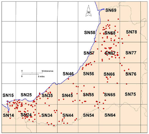
The gazetteers are in Adobe Acrobat (PDF) format. You can download a gazetteer by clicking on the relevant square – it will open in a new window. The reports are large in terms of file size, they vary in size from 1.4Mb to 13Mb and so will take time to download. You can see the size for each file by hovering your mouse pointer over the relevant square.
2006 – 2007– A Survey of Defended Enclosures in Pembrokeshire
In 2006-07, the project continued with visits to all non-scheduled sites and 1 in 10 scheduled sites in Pembrokeshire. There are 367 defended enclosures and related sites in Pembrokeshire broken down into the following site types: Hillfort 9, possible Hillfort 6, Promontory Fort 96, possible Promontory Fort 5, Defended Enclosure 211, possible Defended Enclosure 40. Of these, 127 are Scheduled Ancient Monuments. During the course of the survey it was discovered that most of the larger earthwork monuments, such as hillforts and promontory forts are in a good and stable condition. However, some of the smaller earthwork sites have degraded over the past 30 – 40 years. The report recommended that a further 51 defended enclosures should be scheduled and that the area of three scheduled sites should be reviewed. A recommendation for survey and other recording work was made for many other sites.
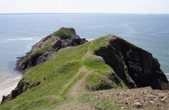
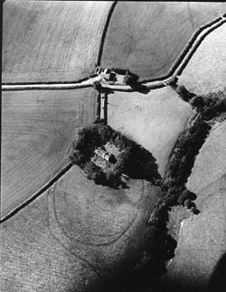
The small, unscheduled promontory fort of Dinas Fach, near Newgale
For ease of handing the site gazetteers have been arranged into Ordnance Survey 10km grid squares. Each gazetteer consists of one or more 1:50,000 maps showing the overall location of each site followed by the individual entries for each site. Each entry comprises: a printout from the Historic Environment Record, including a site description; a 1:500 map; and where available a ground photograph and an aerial photograph. Many of the 1;500 maps show details of the site plotted from cropmarks shown on aerial photographs. These plots are supplied by RCAHMW Crown Copyright ©.
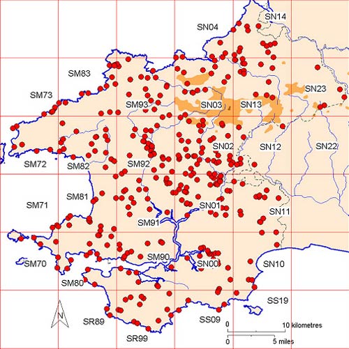
The gazetteers are in Adobe Acrobat (PDF) format. You can download a gazetteer by clicking on the relevant square – it will open in a new window. The reports are large in terms of file size, they vary in size from 2.3Mb to 23Mb and so will take time to download. You can see the size for each file by hovering your mouse pointer over the relevant square.
2007 – 2008 A Survey of Defended Enclosures in Carmarthenshire
Llangan Church, on the sites being examined in this year’s defended enclosure project
In 2007-08, defended enclosures in Carmarthenshire were investigated, with field visits undertaken on the same basis as in previous years. The survey identified 214 defended enclosures and related sites in Carmarthenshire, broken down into the following site types: Hillfort 15, Promontory Fort 32, possible Promontory Fort 1, Defended Enclosure 116, possible Defended Enclosure 36, Enclosure 4, possible Enclosure 10. Of these, 46 are Scheduled Ancient Monuments. During the course of the survey it was discovered that most of the larger earthwork monuments, such as hillforts and promontory forts are in a good and stable condition. However, some of the smaller earthwork sites have degraded over the past 30 – 40 years.
The gazetteers are in Adobe Acrobat (PDF) format. You can download a gazetteer by clicking on the relevant square – it will open in a new window. The reports are large in terms of file size, they vary in size from 3.9Mb to 9.8Mb and so will take time to download. You can see the size for each file by hovering your mouse pointer over the relevant square.
During 2008-09 c.30 defended enclosure sites that had not been previously visited were reported on.
A report of this work is downloadable as a pdf (opens in new window).
Also during 2008-9 a series of drawings were produced for a book on Iron Age settlements in Wales to be produced by Cadw with contributions from the four Welsh Archaeological Trusts.
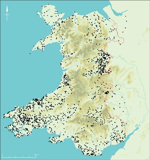
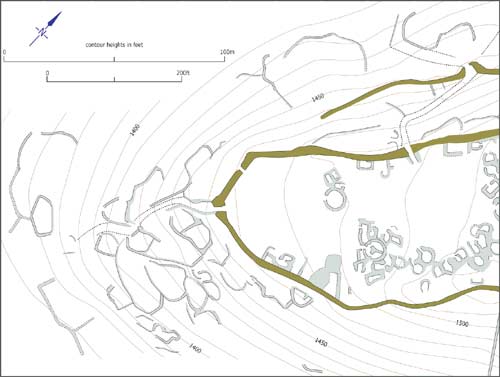
Examples of two drawings: a distribution map showing all Iron Age defended sites in Wales, and a drawing of part of Garn Fadryn
Project Contact: Ken Murphy
